This walk takes you through pretty woods and fields around Chawton in Hampshire. You may, of course, choose to tackle only one of the loops and spend time visiting Jane Austen’s house. The walk was submitted by Guildford Rambling Club (see guildfordramblingclub.org.uk).
Option 1 – 4.5 miles – Chawton to Farringdon.
1. Start from the centre of Chawton in the small car park beside the Cassandra’s Cup café (10am to 4.30pm, but only lunches between 12 noon and 2.30pm). On leaving the car park turn left into the dead end road. Pass the school and later the church (on your left). Also see Chawton House on the higher ground behind the Church of St Nicholas. In the churchyard, at the back, are the graves of Jane Austen’s mother and her sister, Cassandra. The building is Victorian since the church was rebuilt in 1871 after a disastrous fire.
2. Continue along the road to its end and then on along a path in trees. Quickly reach a stile, left, onto a broad grassy track. Go right and parallel to the A32. (This used to be the Gosport turnpike road in Jane Austen’s time). Another stile takes you half-right across a field and through Noar Copse, leading to higher ground beyond. Keep straight on to Berryhill Plantation and continue along the track which is bordered by tall Wellington trees, giving way to yew trees as you descend into Upper Farringdon.
3. Turn left at the edge of the houses. Go through a farmyard with Manor Farm house on your left. Turn right, just beyond a barn on mushroom pillars, towards a large red brick building and then left into the churchyard (hidden in trees) of All Saints. Walk forward from the church porch to a lane. Turn left and, after a short distance, turn right into Crow Lane. Continue along this to reach the Rose and Crown Inn at the T junction with Hall Lane. Turn right and continue straight on between attractive cottages on either side.
4. Turn right into Church Road and take the footpath by the telephone box at the entrance to Parsonage Close and then, on passing the playground, again turn left along track. Reach and cross the A32, with care. Follow the road opposite until a footpath leads off to the right, just before a bridge.
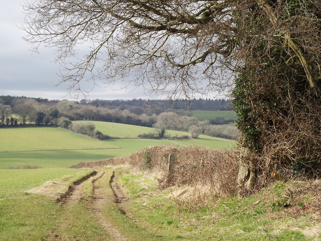
5. Follow this path as it takes you down and along the disused Meon Valley railway line which ran between Alton and Fareham. Continue to the end of the railway track and then along a field edge to the far side where the path turns right. After 50 yards the path turns left into a clump of trees. Go through and on the far side follow a green St Swithun’s Way arrow right. Reach steps down to the A32. Cross, with care. Go up steps and left over a stile and continue along a fenced corridor to Ferney Close. Turn left at the end and walk into the village.
You could lunch in Chawton or you could picnic in the little park next to the car park.
Option 2 – 5 miles – Chawton to Chawton Park Wood
1. Walk back up to the A31 roundabout. Go straight across and up the road opposite. Go under a railway bridge (the Watercress Line) and, a little way beyond it (point * for later in the walk) , turn left along a lane, National Cycle Route 23. Walk for over 1.25 miles whilst you pass a few houses, the lane becomes a track, you ignore rights, you pass a Chawton Farm information plaque and go through various gates. Much of this will have been on a wide straight track through Chawton Park Wood. Eventually the trees are further back from the track and you pass a wide grassy track left, up into the trees.
2. Then, 250 yards later, you take another wide dirt track left and climb a long slope. At the top, at a cross path (wide on the right, narrow on the left), go left. The path winds through close trees and then across a more open stretch with lumps and bumps. Reach a T junction with a wide dirt track and go left. You are on Peter Wyke’s Way and you will walk along it for about 1.25 miles. The first 600 yards bring you to Bricklin Farm. You go straight through and follow the path past Tongham Auto Club’s race track and eventually emerge on the road close to point *. Turn right, walk to the A31, cross and walk back to the start.

DISTANCE: 4.5 and 5 miles
OS MAPS: Explorer 133 Haslemere & Petersfield and Explorer 132 Winchester, New Alresford & East Meon
STARTING POINT: Chawton village car park GU34 1SB
Top image: Meon Valley by Farringdon, Colin Smith.


